IUCN/SSC Otter Specialist Group Bulletin

|
©IUCN/SCC Otter Specialist Group Volume 29 Issue 2 Pages 70 - 120 (June 2012) Citation: Carvalho-Junior, O., Fillipini, A. and Salvador, C. (2012). Distribution of Neotropical Otter, Lontra longicaudis (Olfers, 1818) (Mustelidae) in Coastal Islands Of Santa Catarina, Southern Brazil IUCN Otter Spec. Group Bull. 29 (2): 95 - 108 Distribution of Neotropical Otter, Lontra longicaudis (Olfers, 1818) (Mustelidae) in Coastal Islands Of Santa Catarina, Southern Brazil Oldemar Carvalho-Junior1 , Alexandre Fillipini2, and Carlos Salvador3
1Instituto Ekko Brasil, IEB, Brazil . e-mail:
atendimento@ekkobrasil.org.br
|

|
| (Received 11th April 2012, accepted 13th July 2012) |
| Abstract: This study presents the distribution of neotropical otters (Lontra longicaudis) in coastal islands of Santa Catarina State. A total of 23 islands were surveyed, through 46 field trips. Otter's signs were found in 9 islands, representing 39% of the total. It is believed that the Lontra longicaudis use these islands as a support for its movement from one place to another. The results could be indicating the existence of a coastal ecological corridor used by the neotropical otter. |
| Keywords: |
| Française | Español | Português |
INTRODUCTION
Distribution of Lontra longicaudis in marine habitats along the coast of Brazil is poorly known. The neotropical otter in Brazil is often recorded in rivers, estuaries, mangroves, lakes and lagoons ( Carvalho-Junior, 1990 ; Helder and Andrade, 1997 ; Pardini, 1998 ; Quadros and Monteiro-Filho, 2001 ; Alarcon and Simões-Lopes, 2004 ; Quintela et al., 2008 ; Carvalho-Junior et al., 2010a , b ). However, citations of neotropical otter on coastal islands are rare.
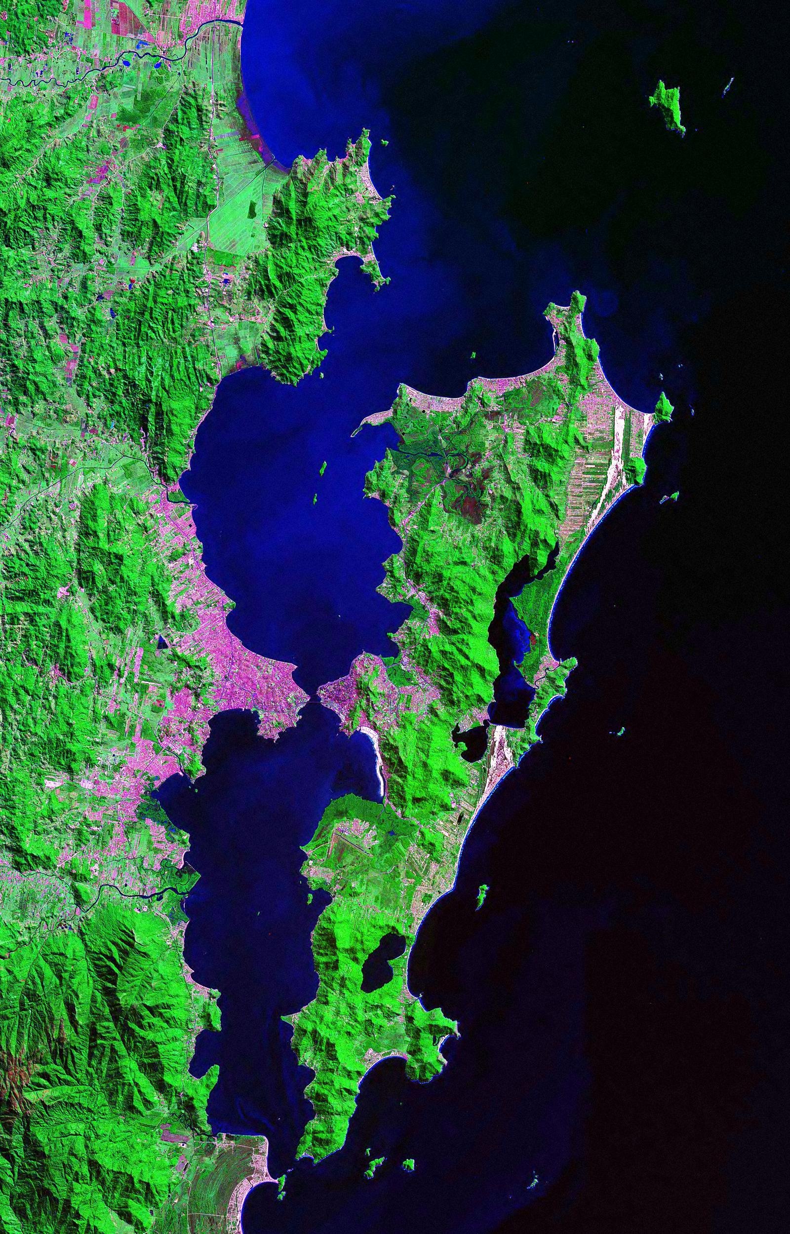
Santa Catarina state has at least 130 islands, Santa Catarina Island (Florianópolis) being the largest one ( Figure 1 ). The island of Santa Catarina has an average length of 54 km and width average of 18 km. It has several bays, promontories, islands, bays and lagoons. The island is located parallel to the mainland and separated by a narrow channel.
Some islands are distant from the mainland such as Badejo Island (21.2 km), Xavier Island (17.8 km), Mata-Fome Island (16.4 km), Campeche Island (16.0 km) and Arvoredo Island (12.62 km). If the presence of Santa Catarina Island is taken into account , some distances can be reduced. Campeche Island, for example, is 16 km away from the mainland, but only 1.4 km distant from Santa Catarina Island. Arvoredo Island, on the other hand, is located north of Santa Catarina Island and its distance from mainland and from Santa Catarina Island is similar, 10.6 km.
 |
|
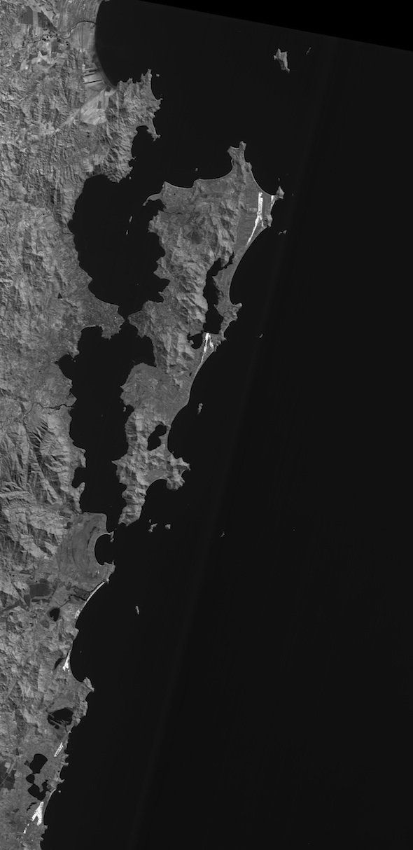
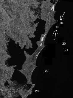
Figure 1.
Landsat satellite photo of Santa Catarina Island (Source:
https://zulu.ssc.nasa.gov/m
). The two main lagoons are shown, Peri Lake in the south and Conceição Lagoon in the north. (click for larger version) |
The presence of Lontra longicaudis on islands close to the mainland of Santa Catarina state (less than 1 km), has been reported before. Anhatomirim Island ( Alarcon and Simões-Lopes, 2004 ) and Porto Belo Island (João da Cunha Island) ( Carvalho-Junior, 2007 ) are known for the presence of the species throughout the year. However, a comprehensive study of the distribution of the species on costal islands has never been carried out before.
Carvalho-Junior et al. (2004) studied the distribution and characteristics of environments used by the neotropical otter in the coastal region of Santa Catarina State, Brazil. It is important to point out the indented coastline of the state. It is replete with small bays and promontories that can in turn result in different effective distances between mainland and islands, depending on the angle the observer uses.
The coastal area of Santa Catarina is also rich in lakes, lagoons and river mouths. The largest number of lagoons on the mainland is located between Arvoredo Island (27°17'98" S/48°21'53" W) and Lobos Island (28°26'48'' S/48°42'33'' W). This area has a number of lakes that includes (from south to north), the Camacho Lagoon (6.32 km2), Santo Antonio Lagoon (33.85 km2), Imaruí Lagoon (86.32 km2), Mirim Lagoon (63.77 km2), Ibiraquera Lagoon (8.65 km2) and Garopaba Lagoon (5.15 km2), along with several rivers flowing into the sea.
In Santa Catarina Island the most important water bodies are the Peri Lake (5.1 km2) and the Conceição Lagoon (19.71 km2) ( Figure 1 ). To the north of Santa Catarina Island there are more river mouths such as Tijucas River, Itajai-Açú, Itapocu River, and Babitonga Bay in the extreme north of the state. The presence of promontories is also significant such as Penha, Porto Belo and Governador Celso Ramos Promontories (Figure 2).
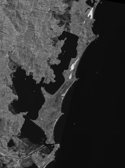
Distribution of otters on coastal islands, further away from the continent, such as Campeche Island and Irmã-do-Meio Island, has been reported only recently (Carvalho-Junior, 2007), suggesting that the presence of the Lontra longicaudis in marine environments could be more widespread than expected. This work represents a record of the presence of Lontra longicaudis in coastal islands of Santa Catarina State located between 26°42`33” S and 28° 32` 21” S ( Figure 3 ).


MATERIALS AND METHODS
Each island was inspected on foot, from 6:00 AM to 06:00 PM, searching for signs of otters. Indirect signs of the presence of otters were considered to be footprints, feces, scent marks (urine and mucus) and the presence of active shelters. The islands were visited twice: Fall/winter and spring/summer 2007/2008.
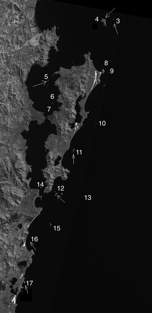
The organization and planning of field trips included preliminary data collection, such as maps, aerial photos, satellite images and selection of the islands to be visited. The study area chosen was the one with the islands scattered in the central coast of Santa Catarina. The 23 islands selected for research and their locations can be seen in Figure 3 and are listed in Table 1 .
The fieldwork on each island was considered complete after the entire surface had been explored. The time spent on each island varied depending on the size and difficulty of movement due to density of vegetation and topography.
Small islands which are flat and smooth, such as Guarás-Pequeno, Guarás-Grande, Cardoso, Itacolomis, Santanas and Ilhota Islands, were examined from 30 minutes to 3 hours. Larger islands such as Arvoredo, Irmã-de-Dentro, Moleques-do-Sul and Corais took longer, resulting in 1 to 3 days of fieldwork.
A total of 23 field trips were conducted in the spring/summer, totaling 127 hours worked, and 21 field trips in the fall/winter, with 105 hours worked. The total effort was 44 visits, corresponding to 232 hours of research.
RESULTS
According to Filippini (2009) , on the 23 islands, 14 different habitats were classified: supralittoral rocky, supralittoral sandy, mesolittoral rocky, mesolittoral sandy, herbaceous vegetation, shrub vegetation, arboreal vegetation, disturbed vegetation, wetland, ground, cave, lagoon, creek and edification.
All 23 islands surveyed presented the supralittoral rocky habitat, dominated by rock, absence of vegetation, subjected to solar radiation, rain, wind and marine spray. All islands have rocky supralittoral zone. Lontra longicaudis signs were found in this habitat, together with Zonotrichia capensis, Pitangus sulphuratus, Chatartes sp, Tupinambis sp, Sula leucogaster, Phalacrocorax brasilianus, Otaria flavescens, Arctochephalus australis, domestic goat, Larus dominicanus, and Thalasseus sp. In total, 40 species of vertebrates were found in the supralittoral rocky habitat.
The supralittoral sandy habitat is found between the end of the vegetation and the high tide. This habitat was found on five islands: Ratones-Grande, Guarás-Grande, Guarás-Pequeno, Campeche and Corais. Signs of neotropical otter were not found in this region. Other vertebrates observed in this habitat consist mainly of Larus dominicanus, Coragyps atratus, and domestic goats.
The mesolittoral rocky zone represents the rocky surface covered by marine benthos, positioned between the maximum high tide and the low tide. All 23 surveyed islands have rocky mesolittoral zone. 20 vertebrate species were found to inhabit this zone. The typical species is the Haematopos palliatus (American Oystercatcher), adapted to feed on molluscs in the rocks. Other vertebrates are the Larus dominicanus, Zonotrichia capensis, Troglodytes musculus, Pitangus sulphuratus, Ceryle torquata, Charadrius semipalmatus, three species of Scolopacídeos and five species of the Ardeidae family. Where otters were observed in the supralittoral zone it is likely that they also use this zone.
The mesolittoral sandy is the habitat formed by the intertidal action on sandy beaches. The islands that presented mesolittoral sandy were: Ratones-Grande, Guarás-Grande, Guarás-Pequeno, Campeche and Corais. Five species were observed in this region: Larus dominicanus, C. atratu, Haematopos palliatus, Polyborus plancus and Zonotrichia capensis. As for the supralittoral sandy, signs of neotropical otter were not found in this region.
The herbaceous vegetation habitat is formed predominantly by herbaceous vegetation with up to a meter height. It is present on 14 islands and appears along the cliffs, flat areas and wetlands, overlying sandy deposits. The most common plants are Ipomoea, Panicum, Paspalum, Spartina, Remirea, Lantana, Tibouchina, Vitex, Aechmea, Vriesea, Cereus, Opuntia, and Polypodium. 34 species of vertebrates were observed in this habitat, including Larus dominicanus and Sula leucogaster. It is also common to see forest birds, such as G. aequinoctialis, B. culicivorus, Troglodytes musculus, Zonotrichia capensis, Pitangus sulphuratus, Coragyps atratus, Speotyto cunicunaria, Milvago chimango, Milvago chimachima, Polyborus plancus, Rupornis magnirostris and Syrigma sibilatrix. Other species are lizards, snakes, rabbits and rodents of the Cavidae family.
The shrub vegetation habitat consists of shrubby plants from 1 to 5 meters tall, and was found on 15 islands. As for herbaceous vegetation, it is found overlying sandy deposits along the coasts. The main species of vegetation are Schinus terenetifolius, Ocotea sp., Butia capitata, Eugenia sp., Myrcia sp., Vitex sp., Campomanesia sp., Tibouchina sp., Guapira opposita, Myrsine sp., Psidium sp., Tabebuia sp., Cereus and Opuntia. 42 species were observed in this habitat, consisting mainly of birds adapted to a more diverse plant condition. Tyrannus melancholicus and Guira guira are frequently seen in this habitat. The presence of birds adapted to the shade and humidity of trees were also recorded, such as Turdus sp. (Muscicapidae), Elaenia sp. (Tyrannidae), Vireo chivi (Vireonidae), Ranphocelus bresileus, Thraupis sayaca, and Coereba flaveola (Emberezidade).
Trees with height greater than 0.5 m form the arboreal vegetation habitat. The main species are Clusia sp, Syagrus romanzzofiana, Alchornea sp., Ficus sp., Coussapoa sp., Inga sp., Nectandra sp., Ocotea sp., Psidium sp., Ilex sp., Cecropia sp., Myrsine sp., Eugenia sp., Guapira opposita, Gomidesia sp., Myrcia sp., Citharexylum miriantum, Cupania sp., Tabebuia sp., Hibiscus sp. and Huberia sp. The largest number of vertebrates, with 48 species, inhabits this habitat. The typical species are those adapted to shadows and humidity of the forest, such as Chiroptera, Muscicapidae, Tyrannidae, Colubridae, Hylideos and Didelphis sp.
The disturbed vegetation habitat is formed by exotic vegetation. Often this habitat is close to buildings. It was found on 9 islands and it is inhabited by 30 vertebrate species, which are mainly native and domestic introduced animals as birds (Troglodytes musculus, Zonotrichia capensis and Pitangus sulfuratus), lizards (Tabebuia sp), Brazilian Game Fowl, ducks, geese, chickens, cats and dogs.
The wetland habitat is formed in depressions due to the accumulation of rainwater or groundwater, accompanied by vegetation adapted to flooding. The most common species are the grasses Paspalum sp, Spartina sp, Scirpus sp, Cyperus scleria and Typha sp. Four wetlands were found on 3 islands: The Mata-Fome, Xavier and Corais. Three of these habitats were in the high parts of the islands and a fourth was located near sea level. Only amphibians were found to be using this habitat.
The ground habitat consists of the soil or substrate formed on the basement rock, usually covered by vegetation. Three species were found to be using this habitat: a snake Amphisbaena sp., an owl Speotyto cunicunaria and a rabbit Oryctolagus cuniculus.
The cave habitat represent natural rocky cavities, accessible to man, with variable dimensions, with only temporary short time periods of light, a higher thermal stability inside than the outside and a relative humidity that tends to saturation. Four caves were found on three islands: Arvoredo and Batuta Islands with one cave each, and Feia Island with two caves. These caves are located between 2 and 3 meters above sea level, at the interface between the supralittoral rocky and native vegetation. Neotropical otter signs were found in two caves, one at Batuta Island and another at Arvoredo Island.
The Batuta Island cave opens to the north, 3 meters wide and 5 meters long, 1 meter high and at 3 meters from sea level. It consists of a narrow corridor with walls and floor of granite. The end is covered with rocks and sediments from which runs a trickle of water drainage. The Arvoredo Island cave opens to the west, 1 meter wide, 5 meters long, 1 meter high and at 1.5 meters from sea level.
No signs of otters were found at the two caves of Feia Island. The first opens to the south, 8 meters wide, 60 meters long, 3 meters high and at 2.5 meters from sea level. The second opens to the north, 6 meters wide, 30 meters long, 4 meters high and at 2 meters from sea level.
The lagoon habitat is formed by a calm and shallow water body that maintains a restricted communication with the sea, with a salinity that can vary from almost fresh to hypersaline. This habitat is found only at Siriú Island. This is a small oval lagoon, 36 meters wide, 10 meters long and 1.50 meters deep, located in the center of the island and surrounded by rocks. The water of this lagoon is formed by mixing of rainwater with seawater that penetrates through a gap of 31 m located on the floor at the east side of the island. Three species of crabs were found in the lagoon: Chasmagnathus granulata and Callinectes sp. Only two species of vertebrates were found in the lagoon: Larus dominicanus and Lontra longicaudis.
The stream habitat is a small perennial water flow. Two streams were found on Arvoredo Island. One is approximately 550 m long and the other is approximately 1100 m long. Both are perennial and completely hidden in the Atlantic Forest that covers the island. The waters of the two streams are limpid, flowing through rocks, gravel and fallen logs. There were no fish but the crustacean Macrobrachium sp is common. This crustacean is one of the favorites in the diet of neotropical otter ( Carvalho-Junior, 2010b ). Signs of Lontra longicaudis were found at the longer creek.
The buildings habitat is the one constructed by man. It consists of houses, cottages, restaurants, fortifications, sheds, lighthouses, piers, water tanks, septic tanks, solar panels, stairs, walls, bathrooms, toilets, walkways or some kind of ruin. Among the islands surveyed, 11 exhibited some type of building. The island containing the smallest constructed area is Mata-Fome: a shack of 6 m2. The island with the largest constructed area is Campeche, with 2 restaurants, 6 houses, a lodge, 2 barbecue grills, a bathroom, 2 power houses, a gas tank, 4 water tanks and 3 walkways, summing up all together 1700 m2. Arvoredo Island presents a lighthouse, 4 homes, a lodge, a powerhouse, 9 solar panels, a fuel shed, a warehouse and 13 water tanks. Lontra longicaudis was found at Arvoredo and Campeche Islands, but not in the buildings areas.
The Islands and the neotropical otter
Itacolomis Islands are two granitic islands separated by a 30 meter wide channel. They are 6.2 km away from the mainland, approximately 25 and 40 meters high, 40 and 65 meters long respectively, with a total area of 0.52 ha. There are no buildings on these islands. The total coastline is 393 meters; maximum width is 26 and 52 meters each, with steep topography. The islets are used for research, camping and fishing, but not by the neotropical otter.
These islands are located furthest north in relation to the other surveyed islands. The surface of the islands is 62.63% rocky. In the upper areas of the southern promontory we found mainly herbaceous vegetation (31.33%), consisting of grasses and clumps of cactus, Opuntia sp, Guapira opposita and Spinacia oleracea. Shrubs appears only on the northern promontory, formed by groups of Opuntia sp., covering 6.02% of the surface.
Feia Island is situated 4 km southeast of Itacolomis and 2 km from the coast. It is mountainous, has no buildings, the area is almost 11 ha and it is 80 m high. Its coastline of 1194 meters is very irregular and difficult to walk. The island is 500 m long and a maximum width of 375 m, with an area of 10.95 ha. It has 70% of its area covered by vegetation. It is used for research, camping, visitation and fishing. Most of the coastal coastline (6.32% of mesolittoral and 14.43% of supralittoral) presents several vertical cracks. Two of these cracks were considered caves, inhabited by Streptoprogne zonaris. Lontra longicaudis was not recorded on this island.
Deserta Island has an area of 15.30 ha and is one of the most distant from the coast (15.7 km) and 13.7 km from Santa Catarina Island. The east coast is steep and abrupt with 80 m height and a coastline of nearly 4 km. The island has no buildings. Signs of neotropical otter were found at the west side of the island. The island is covered by 22.22% of clumps of Guapira opposita, 27% by herbaceous vegetation of grasses and bromeliads. The remaining area is 15.13% of mesolittoral rocky and 35.63% of supralittoral rocky.
Arvoredo Island is one of the islands where signs of Lontra longicaudis were found. It is mountainous, 300 m high, with a length of 3.5 km, 1740 m wide and with a coastline of 10.5 km. It has an area of 324 ha and is one of the largest islands surveyed. This island is located 12.6 km from mainland and 10.7 km from Santa Catarina Island. It presents a variety of environments such as rocky coast, small streams of water, Atlantic Forest, dunes, and buildings, such as lighthouse, houses and sheds.
This island exhibits two unique habitats among all islands surveyed: the Atlantic Forest, which covers 80.76% of the surface of the island, and two perennial streams (0.02%). Lontra longicaudis uses both habitats, at the north of the island. No fish were found in these two streams. During the survey, 36 species of vertebrate were found, including Didelphis aurita, Nasua nasua, Tupinambis merianae, Scinax perereca, a variety of seabirds (e.g. Sula leucogaster and Fregata magnificens), birds such as Egreta thula, Butorides striatus, hawks and forest birds, and domestic species such as dogs and Capra aegagrus hircus.
Mata-Fome Island is a small island of 3.49 ha, 40 m high and with a coastline of 1225 m. It is relatively close to Santa Catarina Island (690 m) but 16.4 km away from the mainland. It has a small hut used by fishermen. In the central and highest portion of the island, there is a wetland with Typha dominigensis. No amphibians or other vertebrates were found in this habitat. Herbaceous grasses and bromeliads compose the vegetation; however the supralittoral rocky habitat is predominant (48%).
Badejo Island is located 2.4 km southeast of the Mata-Fome Island, 1 km north of the of Santa Catarina Island and 21.2 kilometers from the continent. The island is relatively small (2.84 ha), with steep topography and low altitude (35 m). It is 333 m long, with a coastline of 1168 m and maximum width of 155 m. It is used for research, camping, fishing and leisure. The island is rocky with meso and supralittoral representing 66.89% of the surface. Areas with herbaceous vegetation and shrubs are 33.14%. Vertebrates found on the island were birds (Sula leucogaster, Coragyps atratus, Milvago chimachima, Milvago chimango, Haematopus palliatus, Larus dominicanus, Sterna hirundinacea, Pitangus sulphuratus, Troglodytes aedon, Zonotrichia capensis) and one species of lizard Hemidactylus mabouya.
Ratones Grande Island is located 4.6 km from mainland and 2.3 km from Santa Catarina Island. It presents an area of 21.22 ha, 1 km long, 280 m wide and 44 m high. The total coastline is 2726 meters, mainly rocky. The island is covered by Atlantic Forest and the main building is a historic building, the Fortress of Santo Antonio, built in 1740. 33 vertebrate species were found, including 53 species of birds, 5 mammals, 5 reptiles and 1 amphibian. Among the mammals were the opossum D. aurita, a bat M. nigricans, and Lontra longicaudis.
Guarás-Pequeno Island was the smallest island with 0.25 ha, 1.7 m height, length of 45 m and a coastline of 512 m. It is situated within the North Bay, 2.4 km from Santa Catarina Island and 4.0 km away of the continent. This island is used mainly for camping and fishing. The only building is a barbecue place. The coastline of the island is rocky with a short sandy beach of 5 meters length. The centre of the island is covered by shrub. Mammals were not found on the island.
Guarás-Grande Island is also located in the North Bay, 2.4 km north of Santa Catarina Island and 3.7 kilometers from mainland. It has 1.1 ha, 5 m height and 171 m length. The west side of the island has small beaches separated by rocks. The east side is mainly rocky with some areas of sand. Buildings on the island include two warehouses, a house, a kiosk, solar panel, two water tanks, one chapel and a barbecue. Most of the original vegetation was replaced by exotic vegetation where chickens and dogs walk freely. Neotropical otter was not found in the island. The island is used for military training.
Xavier Island has an area of 8.71 ha and height of 50 m. The topography is steep and the length of 607 m is almost three times its maximum width (219 m). It is located 3.6 km east of Santa Catarina Island. This island is used mainly for research, camping, leisure and fishing, but there are no buildings. The coast of the island is all rocky with no beaches or springs of fresh water. The northern tip is only slightly higher than the rest of the island, allowing the formation of relatively flat areas, including the largest wetland of all the islands surveyed. The shrub vegetation covers 20.37% of the surface while herbaceous covers 48.82%. The terrestrial vertebrate fauna recorded is represented by 17 species, 14 birds, 2 mammals (Oryctolagus cuniculus and Artocephalus australis) and an exotic reptile (Hemidactylus mabouya).
Campeche Island is mountainous, with 53.56 hectares, a coastline of 5.5 km, 82 meters height, length of 1620 meters and maximum width of 560 meters. It presents rocky shores and a sandy beach of 500 meters long. This island is located 1415 m east of Santa Catarina Island and 16 km from mainland. It is covered by Atlantic Forest. The buildings (seven houses, bathrooms, two restaurants, four water tanks, barbecue places) cover approximately 1700 m2, 0.31% of the surface of the island. The trees represent 58.51% of the area, followed by shrubs with 11.89%. This island is used for research, fishing, visitation, environmental education, and commerce. In the rocky supralittoral zone, three latrines of the neotropical otter were found. Different species of birds and mammals such as Didelphis sp, Nasua nasua, Dasyprocta azarae, Mus musculus and Arctocephalus sp. are also part of the fauna in the island.
Cardoso Island is located in the South Bay, 1.5 km away from Santa Catarina Island and 1.23 km from the continent. The relief is undulating and approximately 8 m high, 145 m in length, a coastline of 358 meters, maximum width of 80 meters and an area of 0.78 ha. It is used for signaling, boating, camping, fishing and research. The meso and supralittoral rocky represent 43.22% of the area of the island while herbaceous vegetation covers 56.76% of the surface. The terrestrial vertebrate fauna recorded on the island consists of 13 species, 11 birds, a mammal and an exotic reptile. Signs of Lontra longicaudis were not found on this island.
Irmã-do-Meio Island presents an area of 55 ha and a height of 103 m. Atlantic Forest covers 67.60% of its surface. The remaining is 14.75% of shrub distributed on the exposed side (east) and 0.26% of disturbed vegetation located on the north side of the island. The island has no permanent water and no buildings. It is used for fishing, camping and visitation. 33 species of vertebrates, 27 birds, 3 mammals (Didelphis aurita, a bat and the neotropical otter), two reptiles (Tupinambis merianae, Hemidactylus mabouya) and a frog (Leptodactylus cf. gracilis) were recorded. Along the nearly 6 km of coastline, in the rocky supralittoral zone, the presence of otters was verified from two latrines and a cave.
Moleques-do-Sul Island has no beaches and no caves. The island has an area of 10.6 ha with maximum width of 275 m. The coastline is 2464 m, with a length of 705 m and 115 m high. It is 14 km from mainland and 8 km from Santa Catarina Island. The island has no fresh water. The rocky area (supra and mesolittoral) covers 32.10% of the surface of the island. It is the only one of the 23 islands surveyed that has all three habitats of native vegetation (trees, shrubs and herbaceous). The vertebrate fauna includes 29 species, 26 birds, one mammal (Cavia intermedia) and one reptile (Amphisbaena sp.). The island is used for fishing, camping, research and collecting mussels. The neotropical otter was not found on the island.
Coral Island is 4.6 km distant from mainland. It has an area of 31.28 ha, length of 1130 m, maximum width of 406 m, height of 65 m, and a coastline of 3315 m. The terrain is mountainous. It is used for fishing, collecting mussels, visitation, catching birds, camping and nautical signage. The buildings include a lighthouse, a chapel and a staircase. Shrub represents 49.71% of the area and arboreal vegetation 23.60%. There are two wetlands. 35 species were found: 3 mammals (Didelphis aurita, Arctocephalus australis, Capra aegagrus hircus), 27 birds, 3 reptiles and 2 amphibians. Neotropical otter was not found on the island.
Siriu Island is a small island of less than 2 ha, 12 m height, 220 m long and a coastline of 744 m. The distance from mainland is 1167 m. The lagoon is a small body of water in the central part of the island maintained by rain and seawater. The area is used for fishing, camping, collecting mussels, visitation and research. The herbaceous vegetation accounts for 19.19% of the area. The rocky surface covers 79.10% of the island in which 44.33% is supralittoral and 34.77% is mesolittoral. The island is used by the neotropical otter. Otter feces were found in the rocky supralittoral zone. The vertebrate fauna of the island is 14 species, 11 birds, one mammal (the neotropical otter), a reptile and an amphibian.
Batuta Island is situated at 350 m from the mainland, in front of a lagoon (Ibiraquera Lagoon). It is 40 m height with an area of 8.17 ha, length of 343 m, maximum width of 307 m and a coastline of 1210 m. The island is used for fishing, collecting mussels and visitation. The surface is 64.51% shrubs, 5.35% herbaceous and 0.21% disturbed vegetation. There is a cave on the north shore used by the neotropical otter. 29 species wre recorded: 23 birds, 4 mammals, an amphibian and a reptile.
Santana-de-Dentro Island is very close to the continent (82 m). It has 3.72 ha, a coastline of almost 1 km, length of 270 m, maximum width of 172 m and 12 m height. Southeast of the island there is a natural salt-water pool with 7 m diameter and 3 m depth. The island is used for fishing, collecting mussels and visitation. There is no buildings in the area. The herbaceous vegetation covers 53.57% of the island. The other half is rocky (15.83% supralittoral and 30.58% mesolittoral). It was found 12 species, 11 birds and a mammal, the neotropical otter. Signs of the otter were found along the rocky shore.
Santana-de-Fora Island has 4.59 ha and is located 540 m from the mainland. It is 25 m height, with a coastline of 1155 m, 277 m of length and width of 197 m. The island is used for fishing, visiting and collecting mussels. There is only one house in the island. The rocky supralittoral represents 28.84% of the area and herbaceous vegetation covers 54.24% of the island. The supralittoral rocky is also used by the neotropical otter. Besides the otter, 14 species of exotic birds and a reptile were recorded.
Araras Island is an island with nearly 10 ha, 779 m in length, maximum width of 155 m, maximum height of 44 m and a coastline of 2512 m. This island is used for fishing, collecting mussels, research and visitation. There is a lighthouse and a cottage. The vegetation is predominantly shrub (27.52%) and herbaceous (13.94%). The rocky supralittoral occupies 40.33% of the island, followed by rocky mesolittoral with 15.63%. 19 species, 14 birds, 4 mammals and one reptile were recorded. Signs of neotropical otter were not found.
Tacami Island is one of the smaller islands (0.73 ha and 377 m coastline), 9.6 km away from the continent. It has a length of 87 m, maximum width of 53 m and 15 m height. It is used for fishing. The herbaceous vegetation occupies only 13.78% of the surface while the rocky area represents 86.21% of the island. Only five species of birds have been recorded. Signs of neotropical otter were not found on the island.
Lobos Island has 8.7 ha, height of 20 m, 400 m in length and maximum width of 284 m. It has a coastline of 2 km and is 3.7 km away from mainland. It is used for fishing, collecting mussels and camping. The island has a lighthouse for boating signage. There are two dominant habitats, the rocky supralittoral (41.98%) and vegetation (40.79%). 12 species, 10 birds, a mammal and an exotic reptile were recorded. Signs of neotropical otter were not found in this island.
Finally, the Ilhota Island has an area of 2.38 ha and it is 15 m high. Has a length of 233 m with a maximum width of 147 m and coastline of 947 m. It is located 156 m from the continent. It is used for fishing, collecting mussels, camping and research. The supralittoral rocky represents 44.13% of the total area while the mesolittoral rocky is 30.51%. The vegetation is predominantly shrub (22.62%) and herbaceous (2.72%). 21 species, two mammals and 18 species of birds were recorded. Signs of neotropical otter were not found on this island.
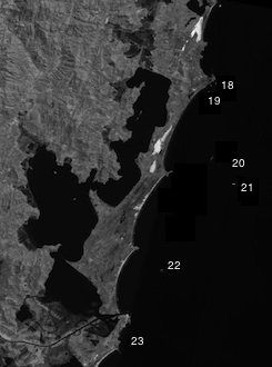
Therefore, from the total number of islands visited, 9 (39%) showed signs of otters: Arvoredo, Campeche, Deserta, Ratones-Grande, Irmã-do-Meio, Siriú, Santana-de-Dentro, Santana-de-Fora e Batuta ( Figure 4 ). Table 2 shows the main habitats in the islands where signs of otters were found.
|
 |
|
Figure 4.
Islands where presence of the neotropical otter was recorded. (click for larger versions) |
|
DISCUSSION
Altogether, 98 species of vertebrates were recorded on the 22 islands surveyed: 75 birds (76.53%), 14 mammals (14.28%), 6 reptiles (6.1%) and 3 amphibians (3%). The neotropical otter appeared in 9 islands. Places where otters were observed were mainly related to the interface between sea and land.
The presence of otters was related to the rocky supralittoral zone associated with Atlantic Forest, caves and fresh-water (Arvoredo and Campeche Islands), to Atlantic Forest (Ratones-Grande and Irmã-do-Meio Islands), to shrub and herbaceous vegetation (Deserta Island), to herbaceous vegetation (Siriú, Santana-de-Dentro and Santana-de-Fora Islands), and to shrub, herbaceous vegetation and cave (Batuta Island).
The presence of the otter on these islands can be related to favorable conditions for the animal for short periods of time throughout the year. It can be also related to the ability of the species to perform short distance movements from promontories to islands and from islands to islands, parallel to the coastline. Rivers, lakes and lagoons, located in mainland, might play an important role on these movements, as protection, fresh water and food availability for the animal. Although there are no fish inland on the islands, neotropical otters should benefit from marine fish along the coast of the islands. In this case the supralittoral zone can be used for resting between hunting activities.
Therefore, the presence of otters on these islands might be associated with the availability of supralittoral substrate, caves, freshwater and vegetation. Characteristics of the islands, combined with rivers, lakes and lagoons in mainland, might be representing a large ecological corridor for neotropical movements, facilitating the contact between subpopulations along the coast.
Acknowledgements - This work is sponsored by Petrobras, through Petrobras Environmental Program (Programa Petrobras Ambiental) and Conselho Federal dos Direitos Difusos (CFDD/MJ) - Fundo de Bens Lesados; and supported by Prefeitura Municipal de Florianópolis and IBAMA (Instituto Brasileiro de Meio Ambiente e dos Recursos Naturais Renováveis). We are most grateful to Gaelle Moisand Lachenal and Nathalie Eychenne, former ecovolunteers at the Otter Project, who kindly translate the abstract to French.
REFERENCES
Alarcon, G.G., Simões-Lopes, P.C. (2004). The neotropical otter Lontra longicaudis feeding habits in a marine coastal area, Southern Brazil.
IUCN Otter Spec. Group Bull. 21(1): 24 - 30.
Carvalho-Junior, O. (1990). Aspectos da autoecologia de Lutra longicaudis (Olfers, 1818) no ecossistema da Lagoa do Peri, SC, Brasil. Tese de Dissertação em Hidroecologia. UFSC, Departamento de Biologia. 94 p.
Carvalho-Junior, O., Banevicius, N.M.S., Mafra, E.O. (2004). Distribution and characterization of environments used by otters in the coastal region of Santa Catarina State, Brazil. Journal of Coastal Research, 39: 1087-1089.
Carvalho-Junior, O. (2007). No rastro da lontra Brasileira. Ed. Bernuncia, Florianópolis, Brasil, 112pp.
Carvalho-Junior, O., Birolo, A.B., Macedo-Soares, L.C.P. de (2010a). Ecological aspects of neotropical otter (Lontra longicaudis) in Peri Lagoon, South Brazil.
IUCN Otter Spec. Group Bull, 27 (2): 105 - 115.
Carvalho-Junior, O., Macedo-Soares, L.C.P. de, Birolo, A.B. (2010b). Annual and interannual food habits variability of a neotropical otter (Lontra longicaudis) population in Conceição Lagoon, south of Brazil.
IUCN Otter Spec. Group Bull. 27 (1): 24 - 32.
Filippini, A. (2009). Biogeografia dos Vertebrados de Ilhas de Santa Catarina: destaque em Aves Marinhas e Costeiras. Dissertação - Universidade Federal de Santa Catarina (UFSC). Florianópolis, SC, 351pp.
Helder, J and Andrade, H.K. (1997). Food and feeding habits of the neotropical river otter Lontra longicaudis (Carnivora, Mustelidae). Mammalia, 61: 193-203.
Pardini, R. (1998). Feeding ecology of the neotropical otter Lontra longicaudis in an Atlantic forest stream, south Brazil. Journal of Zoology, London, 245: 385-391.
Quadros, J., Monteiro-Filho, E.L.A. (2001). Diet of the neotropical otter, Lontra longicaudis, in the Atlantic Forest, Santa Catarina State, Southern Brazil. Studies on Neotropical Fauna and Environment. 36(1): 15-21.
Quintela, F.M., Porciúncula, R.A., Colares, E.P. (2008). Diet of Lontra longicaudis (Olfers) in a coastal stream in southern Rio Grande do Sul State, Brazil. Neotropical Biology and Conservation. 3(3): 119-125.
Résumé : Distribution De La Loutre A Longue Queue, Lontra longicaudis (Olfers, 1818) (Mustelidae), Sur Les Iles Cotieres De Santa Catarina, Sud Du Bresil
Ce travail présente la répartition de la Loutre à longue queue (Lontra longicaudis) sur les îles côtières de l'Etat de Santa Catarina. Vingt-trois îles ont été prospectées à partir de 46 circuits. La Loutre est présente sur 9 îles soit 39% des îles étudiées. Il est probable que Lontra longicaudis utilise ces îles comme étape durant ses déplacements d'un point à un autre. Ces résultats pourraient indiquer la présence d'un corridor écologique marin utilisé par la Loutre à longue queue.
Revenez au dessus
Resumen: Distribucion de la Nutria Neotropical, Lontra longicaudis (Olfers, 1818) (Mustelidae) en Islas Costeras de Santa Catarina, Sureste de Brasil
Este trabajo presenta la distribución de la nutria (Lontra longicaudis) en la zona costera de las Islas del estado de Santa Catarina. Esta investigación incluye 23 islas, a través de 46 áreas. Las nutrias están presentes en 9 islas, que representan el 39% de todas las islas estudiadas. Es probable que Lontra longicaudis pase sobre las islas durante sus movimientos de un punto a otro. Estos resultados podrían indicar la presencia de un corredor ecológico marino utilizado por las nutrias neotropicales.
Vuelva a la tapa
Resumo: Distribuição da Lontra Neotropical, Lontra longicaudis (Olfers, 1818) (Mustelidae) em Ilhas Costeiras de Santa Catarina, Sul do Brasil
Este estudo apresenta a distribuição da lontra neotropical (Lontra longicaudis) em ilhas costeiras do Estado de Santa Catarina. O total de 23 ilhas foram amostradas em 46 expedições. Sinais de lontras foram encontrados em 9 ilhas, representando 39% do total. Acredita-se que a Lontra longicaudis utiliza estas ilhas como apoio para deslocamento de um lugar para o outro. Os resultados podem estar indicando a existência de um corredor ecológico utilizado pela lontra neotropical.
Voltar ao topo